July 14, 2019, Bertha Lake
Distance: 10.4 kms return with another 4 kms around lake
Elevation gain: just under 500 m
On Sunday, July 14, Fred and I decided to follow the good weather and head down to Waterton Lakes National Park for a hike. Surprisingly, even though we have lived in Calgary now for almost 25 years, I have only been to Waterton once and Fred has never been. Yes, it is a bit of a drive, but then we have done quite a few day hikes off the Icefields Parkway, which entails a drive almost as long. Hmmm. I am kicking myself a bit that we haven’t ventured south until now. Oh well. Given the spectacular day we had, I am sure we will visit this area again soon.
To be honest, the drive is rather boring at the start. Living in the far NW of Calgary meant a lengthy drive on the Deerfoot just to exit Calgary. Once past Okotoks, not too much captured my eye except the brilliant yellow of the canola fields and the huge wind farms we passed along the way. That said, the drive from Pincher Creek to Waterton was stunning. Rolling hills, unfamiliar mountains and wildflowers galore dominated our views.
Entering Waterton Lakes National Park, we could see evidence of the destruction the 2017 Kenow Wildfire had on the area. Dead trees covered the mountainsides. "On August 30, 2017, after an intense lightning and thunderstorm, Parks Canada detected a wildfire about 10 kilometers from the park boundary, in British Columbia. 2017 was the park’s third-driest summer on record. Exceptionally hot weather, strong winds and extremely dry conditions fueled the extreme behaviour of this fire over the next week. The Kenow Wildfire firmly established itself in Waterton Lakes National Park on September 11, 2017. In the end, the wildfire burned 38,000 hectares, including 19,303 hectares in Waterton Lakes National Park and had a significant impact on built infrastructure in the park. Akamina Parkway (16 kilometers), Red Rock Parkway (15 kilometers), associated bridges, guardrails, signs, picnic areas and parking areas were affected. Over 80% of the hiking trail network had been affected by the Kenow Fire." In fact, many hiking trails are still closed today 😢. The Visitor Centre, Crandell Mountain Campground, many buildings at Canyon Youth Camp, the Alpine Stables, staff housing and associated infrastructure such as water and electrical systems were also destroyed by the fire.
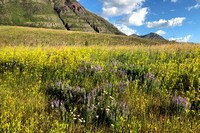
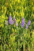
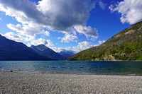
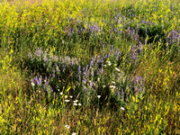
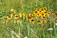
One thing we noticed immediately as we were driving into the park were the wildflowers. I have never seen so many, and so many different wildflowers before. Pictures simply don’t do justice to what we saw. After a quick stop at the front of the lake (Upper Waterton Lake) for pictures, Fred and I headed to the Bertha Lake trailhead. This hike promised to be easy as it was just over 10 kms return and involved just under 500 metres of elevation gain. Walking around Bertha Lake added another 4 kms to the distance. But given the lengthy drive, and Nic’s lacrosse schedule, it was just perfect.
The parking lot was filling up quickly even though it was just past 8:00 am. Fred and I hurried to get packed up and get on our way. The trail is a relatively wide, established one. Many trek up to Bertha Falls, which involves just a gentle incline on just under 2 kms. And then a few continue to Bertha Lake, which involves a series of long (perhaps too long 😮) switchbacks. To be honest, more than once I was wanting to dive into the trees and just head straight up but understanding the impact it would have on the environment and the ridiculous number of wildflowers on both sides of the trail kept me on the switchbacks. I don’t think I have ever seen Fred stop, and stop so many times, for pictures. Many of the flowers I had never seen before. One that I had never come across before was bear grass, which apparently only blooms once every seven years.
Bertha Lake is stunning. I took a ridiculous number of pictures. At first, we headed climbers right and walked about a third of the way around before we retraced our steps back to the front of the lake and heading climber’s left. It seemed everyone was heading right to find a spot for lunch, so we opted to head left. About a third of the way around from this other direction, we stopped for lunch at a beautiful spot full of multi-coloured rocks and a view of Bertha Peak and a gorgeous waterfall. If we had more time, we likely would have scrambled up Bertha ridge and peak but alas, the long drive and the constant stopping for pictures had us leaving the ridge and peak for another day.
The trip down was relatively quick given such an established trail. Just before we reached the parking lot, a storm blew in and then just as quickly as it came, it moved on. We stopped again in front of Upper Waterton Lake for more pictures 😊 and then made the long, scenic drive home. On the way, we were treated to seeing a doe and likely a week or two week old fawn.